Your shopping cart is empty.
Items/Products added to Cart will show here.
Updated April 15, 2024
The southern end of the Superior Hiking Trail is thawing, and some sections are ready for use. North of Duluth, conditions still vary widely and there may still be ice and snow. The MN DNR Snow Depth Map is reporting 2-8 inches of snow pack remaining north of Duluth. Please do not ever hike on groomed ski trails.
Please protect the SHT during mud season.
The Duluth section of the Superior Hiking Trail is open for hiking when dry. Following rain or snow events, please avoid using the SHT between between the 131st Ave. W. Trailhead and Martin Road Trailhead (42 miles), excluding the paved Lakewalk section of the Trail.
North of Duluth, the SHT does not close but we do ask trail users to avoid using the Trail while it thaws.
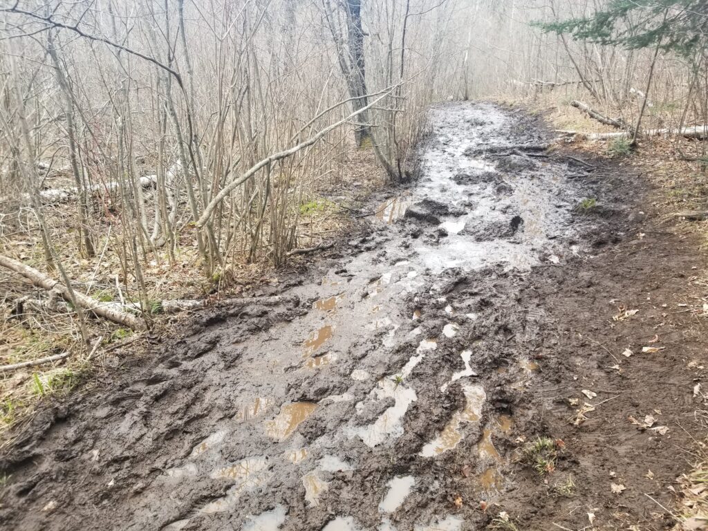
The SHT is most susceptible to damage during spring melt or “mud season”, even by well-intentioned hikers, backpackers and runners. When the snowpack melts, the ground becomes saturated. Spring rainstorms add more precipitation. The Trail turns into mud on top but can still be frozen further down. When our foot strikes the tread, we can cause immediate erosive damage. Trying to go around mud also causes damage, tramples vegetation, and widens the Trail corridor.
![]() Muddy and wet trails should be avoided.
Muddy and wet trails should be avoided.
![]() If you’re leaving footprints in the tread, please turn around and choose another location to enjoy. In Duluth, we recommend the Duluth Winnipeg Pacific (DWP) Trail, Waabizheshikana (formerly Western Waterfront Trail), Campus Connector Trail, Lakewalk, and Cross-City Trail. Along the Northshore, try the Gitchi-Gami Trail, state and national forest roads.
If you’re leaving footprints in the tread, please turn around and choose another location to enjoy. In Duluth, we recommend the Duluth Winnipeg Pacific (DWP) Trail, Waabizheshikana (formerly Western Waterfront Trail), Campus Connector Trail, Lakewalk, and Cross-City Trail. Along the Northshore, try the Gitchi-Gami Trail, state and national forest roads.
![]() If encountering a muddy spot on an otherwise completely dry trail, please go through the mud, not around it, to prevent trail widening.
If encountering a muddy spot on an otherwise completely dry trail, please go through the mud, not around it, to prevent trail widening.
Many trailheads are not plowed in the winter and some roads to our northernmost trailheads are unplowed. The 9th Edition Guidebook and the Databook both list which trailheads are accessible in winter. Always have a backup plan when visiting the SHT in winter in case a trailhead has not been plowed or in case the trailhead is full. Cars have been towed for blocking the path of plows, so please find somewhere else to recreate if the trailhead is full. For a list of trailheads that may be plowed during the winter, click here.
131st Avenue West to 123rd Avenue West
The Sargent Creek Bridge has been removed and replaced with a stone step crossing.
Magney Snively Trailhead to Spirit Mountain Grand Ave Chalet Trailhead
A new reroute was constructed to take the Trail off of Skyline road increasing the safety for our trail users. The reroute is an amazing trail that frames both sides of Stewart Creek with a short stretch along the DWP Trail crossing an incredible bridge with fantastic views.
Waseca Trailhead to Skyline Parkway Trailhead
There is a new reroute open near Green St. taking the SHT off the DWP Trail and into the woods. The SHT still crosses under I35 on the DWP Trail.
Enger Park to Rose Garden
The SHTA and the City of Duluth are aware that there are multiple encampments of people experiencing homelessness in this vicinity. You may experience garbage on and near the Trail, including broken glass among other unsanitary debris. Sturdy footwear is recommended for those who traverse this section.
Rose Garden to Hartley Nature Center
In the Chester Creek area below Skyline Parkway there is Trail damage, use caution near the creek as the Trail may be undercut or damaged.
The boardwalks on the SHT near Hartley Nature Center have been damaged or moved.
Lismore Road Trailhead is open!
The new location is located on the southern side of Lismore Road about a quarter mile from the intersection of Jean Duluth Road and Lismore Road.
Normanna Road Trailhead to Reservoir Road
There is a new reroute around and over the small tributary of the Big Sucker Creek that was dammed by beavers just east of Heron Pond Campsite and west of Reservoir Forest Management Rd. The reroute is well marked and easy to follow.
Gun Club Road to Lake County Road 301/Fors Road: The SHT is closed from Gun Club Road to Silver Creek Campsite.
Long-distance hikers can bypass the area (heading northeast-bound) by following a roadwalk on Gun Club Road to Lake County Road 301 (Fors Road) and reconnecting with the SHT at Lake County Road 301 Trailhead (see map). The Silver Creek Campsite is open for shared use as usual.
Lake County Road 301/Fors Road to Castle Danger
Heading north out of the 301/Fors Road parking lot there is a logging operation currently operating and burning brush piles. Please exercise caution between 301/Fors Road and Hwy 3.
The Encampment River crossing is a shallow ford. Under normal circumstances, it’s an easy crossing with many large rocks. It is only a problem during spring melt or if there has been a large rain event within 48 hours. Here is a roadwalk detour map you can use, but we strongly suggest hiking to the river to assess it before concluding that a roadwalk is necessary.
There are several other shallow fords in this section. This includes Crow Creek near West Castle Danger Road. Like the Encampment River, this creek is rarely high.
West Castle Danger Road to Gooseberry Falls State Park
A small wooden structure has failed near Middle Gooseberry Campsite. Please avoid stepping onto the structure.
The “Gooseberry Gap” Reroute
The Gooseberry Gap Reroute is complete! Here is a map that show the new route!
The Spur Trail from Gooseberry State Park to the main SHT has small areas of slumping along the river, use caution when near the river bank.
Split Rock to Beaver Bay
The eastern side of the Split Rock River Loop will close for a Trail Renewal Project on September 1 and impact 1.8 miles of the main SHT corridor between the western junction of the spur trail to the Split Rock River Wayside Trailhead and the river crossing at the top of the loop.
Trail users will be able to bypass the closed section on spur trails, the same reroute suggested when the river is running too high to ford safely. This closure includes the Southeast and Northeast Split Rock River Campsites. Overnight trail users should plan to use a different campsite on this section for the duration of the closure. To download a map of the closure and reroute, click here.
There is not a bridge over the Split Rock River. Many trail users have crossed the river at the former bridge site during low water. We urge caution if you decide to cross the river. The river may be impassable during high water events. An alternate route exists on spur trails to cross a bridge near Hwy 61 if the water level is high: Northbound, at junction with spur trail turn right (south-east) toward the Split Rock River Wayside. From the wayside, take paved trail to Hwy 61 underpass and turn left. After 0.2 miles, spur trail to main SHT is on left across Hwy 61. Follow spur trail 0.4 miles to junction with main SHT.
Lake County is building a new mountain bike trail, The Split Rock Wilds, near and across the SHT between Split Rock and Beaver Bay. The new trail passes close to the Fault Line Creek campsite. Be aware that there are crews working in the area. Pay special attention to signage and intersections to ensure that you stay on the correct trail.
Penn Blvd to Minnesota HWY 1
A section of the Bean and Bear Lakes Loop will close for a Trail Renewal Project beginning May 15 and impacts 2.2 miles of the main SHT corridor between the western junction of the spur trail to the Bay Area Historical Society Trailhead and an all-terrain vehicle trail to the north of Bear Lake, George’s Gorge Trail. This closure will also impact 1.2 miles of the eastern spur to the Bay Area Historical Society Trailhead between the main SHT corridor and the junction with the western arm of the spur.
Trail users will be able to bypass the closed section using an SHT spur trail and George’s Gorge Trail, an all-terrain vehicle trail. This closure includes the Penn Creek and Bear Lake Campsites, and all Bean and Bear Lake overlooks. Bear Lake Campsite will be rehabilitated as part of the larger renewal project. To download a map of the closure and reroute, click here.
The bridge over High Falls on the Baptism River is closed due to flood damage. Superior Hiking Trail hikers will have to detour south towards the Tettegouche Park Visitors Center to cross the river on the park road bridge. (Map) It is not recommended to do a water crossing at this location above one of the highest waterfalls in the State of Minnesota, please take the reroute.
Sonju Lake Road Trailhead
The Sonju Lake Road Trailhead will be inaccessible beginning June 30th for a road project to replace a culvert on Sonju Lake Road. The project will last between one week and 10 days.
Skou Rd Trailhead to Temperance River Wayside Trailhead
Bridges are washed out between Falls Campsite and The Ledge Campsite along the Cross River. The shallow water crossing is manageable at normal water levels. Please use caution when crossing the river, even small rain events can increase the depth and speed of the water, use your own discretion when crossing.
Oberg Mountain Trailhead and Loop
The first 100 yards to Oberg are severely eroded and the footing is unstable. Use caution while traversing this section.
Leveaux Mountain to Lutsen
The bridge over the Onion River has a weight limit of two people.
Lutsen to Caribou Trail
There are multiple displaced or broken boardwalks in this area due to spring flooding. Please use caution while using these structures.
Agnes Lake Campsite Temporarily Closed and Caribou Spur Trail under construction
There is a trail contractor and crew working on in the area. be prepared to see people working on the Trail. Please do not plan on using the Agnes Campsite July 25 – August 07 as it will be crowded.
Indian Camp Creek Bridge CLOSED
The bridge over the Indian Creek has sustained damage from spring flooding and is currently closed. A shallow water crossing is easily achievable at the narrow creek during normal low water conditions, but please use caution, especially after rain events.
North of Bally Creek Road Road
There is an active logging operation within the first few miles of the Superior Hiking Trail to the north of Bally Creek Road that will continue over the winter.
Arrowhead Trail to Otter Lake Road Trailhead
Carlson Creek Bridge is out on the SHT to the east of Arrowhead Trail Trailhead. This creek can be crossed during normal water levels without this bridge. Please use caution during any shallow water crossing.
The bridge over Andy Creek has been damaged in a recent storm. Please use caution while crossing the bridge or while crossing the shallow cobble streambed.
The pond at South Carlson Pond Camp is gone. The beaver pond that was there was drained most likely by spring flood damage to the existing beaver dam. Since the pond was drained there is not a water source at South Carlson Pond Camp. However there is reported to be a good flow <.25 Mi to the north at a Carlson Creek crossing.
Please respect all Trail and bridge closures set by land managers, State Parks, or the SHTA
You can help us maintain access to the Trail and honor our agreements with private landowners by staying off closed sections. When the Trail is routed through a trailhead, take a moment to check if there are any additional signs posted at the trailhead.
A Rugged, Remote Natural Path
The Superior Hiking Trail traverses many different ecosystems, varies in its proximity to population centers and experiences different levels of use along the length of the corridor. This means a trail user will experience a variety of conditions at different points and will possibly encounter parts of the trail that are rougher than others or a tree may be down. We work hard to coordinate annual maintenance, brushing and log removal but other issues may have occurred since the sawyers have been through an area. This happens on occasion and we will clear it soon or in worst-case scenario it will be clear in the next annual cycle. Please report trail issues as these data points are valuable to us!
Shallow Water Crossings
Shallow water crossings may be impassable during high waters. Spring and fall water levels pose significant risk when crossing, please cross at your own discretion.
A recent high-water event during the spring melt flooded sections of Trail, washed out some small bridges, and undercut portions of Trail along rivers and creeks. Water levels may still be high along the Trail. During high water events, the force of the water can undercut creek and river banks on which the Trail and bridge abutments are built and the structure could be compromised but not visible to the eye. If you come to washed out or flooded Trail and bridges, please use caution.
Wildlife Advisories
The Superior Hiking Trail is a remote natural path trail, because of the solitude and open land there is the opportunity to encounter wild animals. Do not under any circumstances feed or approach any wild animal. It is highly unlikely that an animal poses a threat to you, however, if an animal approaches you it is either sick and needs to be avoided or should be scared away so that it does not become comfortable with you as a potential food source. For this and many other reasons, please keep your dog leashed on every section of the SHT.
There have been wasp nests have been reported near the Trail, please be aware of this as well.
Your shopping cart is empty.
Items/Products added to Cart will show here.
 Adding...